Sun Standing Still

(Originally posted, December 2013)

The word solstice comes from the Latin: sol (“sun”) and sistere (“to stand still”).  As seen from Earth, the sun’s highest point for the day is at its lowest for the year and the movement of the Sun’s path comes to a stop before reversing direction. In the Northern Hemisphere, this takes place on or around December 21st by the Gregorian calendar. As far back as time has been recorded through human monument, the solstice has been an important part of the yearly calendar of life.

In the northern realms of Scotland, one of the most significant markers of the importance of the solstice is at Maeshowe (or, Maes Howe) on the island of Orkney.  Built 5000 years ago, 1500 years before Stonehenge, Maeshowe is a significant architectural achievement. Made of stacked sandstone slabs that are level to within an inch or so, the cairn is entered by a 36 foot long passageway (through which one needs to stoop very low) that opens in to the main chamber which is about 15 feet square and twelve or so feet high.

Unfortunately, the site was “excavated” in 1861 by James Farrer, Member of Parliament, who did not take very good notes about what he was doing, nor did he make an effort to document what he found. He completely removed all the debris he found without searching for any archeological finds contained in the debris. Farrer did find the runic inscriptions that were carved on the interior walls by the Norsemen who had broken in to the tomb themselves in the 12th century. The largest single collection of runic carvings in the world, the carvings may also be the world’s first graffiti; one of the thirty inscriptions reads: “These runes were carved by the man most skilled in runes in the western ocean”.

The Orkneyinga Saga (or, The History of the Earls of Orkney) was written c. 1230 about the history of Orkney for the three hundred years following its capture by the Norwegian king in the ninth century.  The Saga may provide the definition for the name Maeshowe. It is possibly from the Old Norse mestrhaugr  (“The Great Tomb”).  In the Saga, Maeshowe is called Orkahaugr: orka, (signifies “power” or “greatness”), and haugr (“mound”). According to the accounts in the Saga, a group of Viking warriors sought shelter from a terrible snowstorm. The group was led by the Viking, Earl Harald as he made his way from Stromness to Firth at Christmas in 1153. They took refuge during the night in the mound known as Orknahaugr.

“On the thirteenth day of Christmas they travelled on foot over to Firth. During a snowstorm they took shelter in Maeshowe and two of them (his men) went insane which slowed them down badly so that by the time they reached Firth it was night time.”
Orkneyinga saga – Chapter 93

More recently, research has pointed to Norn, the variant of Old Norse spoken in the Orkney Islands, but never used as a written language. Names of places on the islands suffered greatly due to the mis-interpretation of map makers who took the pronunciation of Norn and wrote it in Scots English. Maeshowe is pronounced locally as Mezz(h)oo, or Mezz(h)ow and it is now suggested that maes comes from the Old Scandinavian word mað, meaning “meadow”. This brings the meaning of Maeshowe to “meadow mound”, which indeed it is.

The alignment of the passageway entering Maeshowe is built so that the interior chamber is illuminated by the setting of the mid-winter sun. The movement of the setting sun can be tracked on the far wall of the cairn during the few weeks before and after the Winter Solstice.  The most significant event is the alignment of the passageway with a standing stone located across some fields a half a mile away from Maeshowe.  The Barnhouse Stone is ten feet high and is set in perfect alignment so that the centre axis of Maeshowe’s inner entrance passage is directly aligned with the centre of the Barnhouse Stone. From the entrance to Maeshowe, the line goes directly to Ward Hill on the island of Hoy (Old Norse, Háey, “high island”) at a place where the sun sets 22 days before and after the midwinter solstice. On the day of the Winter Solstice the last rays of the setting sun are directly behind the Barnstone, and shine directly in to the chamber of the cairn.

Excavations at the entrance to Maeshowe revealed a socket at the entrance that may have held another standing stone, similar to the one at Barnhouse, completing the alignment between the setting sun and the cut area at the back wall of the Maeshowe cairn. Unfortunately, due to the way history has treated Maeshowe, there is no archeological evidence to explain the purpose of the mound and the cairn beyond its being lit at the end of the Winter Solstice day. (There is a connection between Maeshowe and the Ring of Brodgar, though, because the Barnhouse Stone also makes a line that greets the rising sun through the center of the Ring on Beltane, May 1st ; and, when standing in the center of the Stones of Stenness, Maeshowe is seen aligned in between two smaller stones set side-by-side.)

The obvious speculation as to the importance of the Winter Solstice is that the longest night of the year turns to increasingly shorter nights, longer days, and the days of plenty.  But people could not be certain they would survive the bitterest part of winter, which was just ahead.  Winter Solstice would have been the last celebration before the hard times.  Livestock were slaughtered so they wouldn’t have to be fed during the coldest months. This meant feasting on fresh meat for the last time until spring. The fermented drinks that had been put up in the summer were ready to be consumed.  And so, the celebrations began: celebrations that marked moving out of the darkness and turning toward the light; the re-birth of another year; new beginnings.

The centerpiece of the Solstice celebration was the Yule Log.  Yule
derives from the Old Norse, jol  (“feast”) and originally referred to the entire winter season.   Ash wood was traditionally used for the Yule Log; ash being an herb of the sun, it brought the sun’s energy into the house at the darkest time of the year. The wood of the ash burns with intense heat, even when green.  The log was decorated with evergreen boughs, doused with ale, dusted with flour and then lit from a piece of wood saved from the previous year’s Yule Log.  The Log would burn through the night and then be left smoldering for 12 days after which it was ceremonially extinguished.

Evergreen trees were sacred to the ancients because they did not “die” but kept their greenery throughout the year, signifying immortality and the holding of the sun’s energy. Wheat was symbolic of the harvest, the flour signified health and life. Holly and ivy were also brought inside the houses as an invitation for the Nature Sprites to join in the celebration. Holly was kept near the door all year long to invite good fortune. Mistletoe, also hung to decorate the home, represented the seed of the Creator.

Along with Christianization, came the blending of ancient ceremonial practices in to the rites of Christmas.  And then….

In the 1600’s, Scotland was “purged of all superstitious observatione of dayes” by the Reformation, led by John Knox.  The celebration of Christmas was seen as papist, and there were two Acts of Parliament “dischairging the Yule vacance” (2 June 1640) and again “dischargeing the Yule vacance” (15 April 1690).  This first Act was partially repealed in 1686, and parts of the second were repealed in 1712. But still, the ways were set and the Church of Scotland did not put emphasis on the Christmas Holidays. What celebrations there were, were done quietly and people’s work schedules did not change.  Christmas Day became a public holiday in 1958, ending the ban that had lasted some 400 hundred years.

Although the Scots now equal the Christmas celebrations in any other country, the New Year celebrations have more of a national importance. While the Winter Solstice celebrations of light had been absorbed into global Christmas pageantry during the 400 years, the Scots still brought the light out at the New Year.  Harkening back to the Norse origins of Yule, Hogmanay is the largest yearly celebration in Scotland. There are a lot of different guesses as to where the term Hogmanay comes from:  Hoggo-nott was the Scandinavian word for the Yule feast; hoog min dag means “great love day” in Flemish; the Anglo-Saxon, Haleg monath means “Holy Month”; and the Gaidhlig, oge maiden means “new morning”.  The most often quoted source is the French Homme est né for “Man is born” and in France the last day of the year when gifts were exchanged was aguillaneuf. In Normandy, presents given at this time were called hoguignetes.

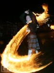
The one that makes the most sense to me is the Norse/ Icelandic haugmenn (“elves”) being banished á læ (“into the sea”). This would take place through the traditional New Year ceremony in which people dressed up in the hides of cattle and ran through the town being hit by sticks. Bonfires were lit and torches were tossed, the smoke from the torches driving off the evil spirits. The smoking torch was called a hogmanay.

Fire ceremonies still take place in the streets of cities and towns for Hogmanay, with the most spectacular display in Stonehaven, (south of Aberdeen on the North East coast). Huge balls of fire, weighing up to 20 pounds, are swung around on long metal poles as men march them up and down the High Street. The origin of this custom is believed to hearken back to the Winter Solstice. The fireballs signify the power of the sun and the smoke purifies the world by consuming evil spirits. The Hogmanay traditions of redding, cleaning the house on the last day of the year to finish with the old, and welcoming guests in to the house with food and song on the first day of the New Year, also have their roots in the fires and feasts of the ancient Winter Solstice-Yule ceremonies and celebrations.

Whether you follow ancient traditions or modern ones, whether you start your year on the Winter Solstice or on January 1st,  “…take a cup o kindness yet, for auld lang syne.”

And have a Guid New Year.


Posted in Ancestry, Auld Lang Syne, Eco-travel, Ecology, Highland Titles, Hogmanay, Land trust, Maes Howe, New Year's Eve, Norn, Orkneyinga Saga, Robert Burns, Scotland, Scottish ancestry, Scottish Christmas history, Self drive Scotland tours, Stonehaven, Stromness, Travel, Uncategorized, Winter Solstice, Women Writers, Yule | Leave a comment

Tartan Day/ Week

This week is Tartan Week, with Tartan Day on Wednesday, April 6 and the New York Tartan Day Parade on Saturday, April 9th. In honor of that, here is a re-post about Tartan Day originally from April 3, 2104.

 Fraser                                  Ancient Hunting Tartan

Fraser Ancient Hunting Tartan

In 1982, Scottish Americans gathered in New York City to celebrate Scottish-American heritage and the contributions that Scots have made to American culture and history. The gathering was organized by the New York Caledonian Club and was declared by both the Governor of New York State and the Mayor of New York City to be Tartan Day. The event was held on July 1st, the 200th anniversary of the repeal of the Act of Proscription which forbade the wearing of the tartan in Scotland.

The Act of Proscription of 1746 incorporated the Dress Act which required all swords to be surrendered to the government and prohibited the wearing of tartans or kilts. The Act remained in force for 36 years, and effectively destroyed Highlanders’ customs and traditions for a generation. The plaid and kilt were never again a part of everyday wear in the Scottish Highlands. This did not prevent the Highlanders from finding a way to honor their traditions; on Sundays they would wear a piece of tartan under their drab “English” clothing, retaining their clan identity and beginning the custom of “the Kirkin’ o’ the Tartan”.                                                                                                                       from Battle for the Battlefield, “Scottish Heart” blog © Kate Cowie Riley

In 1986, the Federation of Scottish Clans in Nova Scotia proposed a ‘Tartan Day’ to promote Scottish heritage in Canada. The Federation petitioned provincial legislatures to recognize April 6 as Tartan Day. Nova Scotia was the first province to make the proclamation in April, 1987. Quebec was the last to do so in 2003. April 6th was chosen for the date in honor of the April 6th signing of the Declaration of Arbroath in 1320.

A letter written to Pope John XXII, the Declaration of Arbroath intended to confirm Scotland’s independence and was signed by thirty-nine ranking Scottish landowners. It asserted Scotland’s sovereignty over English territorial claims and a declaration of Scottish independence against Edward I’s English rule.

The grassroots effort for a National Tartan Day in the US, led by the Caledonian Foundation, began in 1995, and on April 6, 1997 the first National Tartan Day was celebrated in the United States by a Senate Resolution for a one-time celebration. In 1998, Tartan Day was officially recognized on a permanent basis when the U.S. Senate passed Senate Resolution 155 recognizing April 6th as National Tartan Day. This was followed by companion bill, House Resolution 41, passed by the U.S. House of Representatives on March 9, 2005. Four years later, the National Capital Tartan Day Committee and the American-Scottish Foundation jointly promoted a campaign for a Presidential Proclamation for Tartan Day. On April 4, 2008, President George W. Bush signed a Presidential Proclamation making April 6 National Tartan Day.

In 2005, the sword of William Wallace was taken down from the Wallace Monument and left Scotland for the first time in its 700-year history to be taken to New York City as part of the Tartan Day celebrations.   Kyle and I had been debating about trying to climb the 71 stairs of the Wallace Monument to see the sword when we were there in late March of 2005. Considering his injured ankle, we decided against it. We were very happy with our decision when, in the next day’s paper, we read that the sword had been removed the day we were in Stirling. We did get to see it last year, though!

Willaim Wallace Sword Wallace Memorial Stirling

William Wallace Sword
Wallace Memorial
Stirling

Tartan Day has now taken on global importance, and celebrations are held by those of us of Scottish descent as we attend large celebrations such as those in NYC and other major metropolitan areas or smaller Scottish & Celtic Fairs in our own areas. At the very least, there is the wearing of the tartan. So if you see someone wearing a plaid this weekend, it’s quite possibly much more than a fashion statement!

Posted in Ancestry, Scotland, Scottish ancestry, Self drive Scotland tours, Tartan Day, Uncategorized, Women Writers | Leave a comment

Twice a King, In One Day

March 26, 1306

Scotland 2013 TEN 001

Earl of Carrick, Robert Bruce was born at Turnberry Castle, Ayrshire, on July 11, 1274. He was born into an aristocratic Scottish family with both Norman and Celtic ancestry. His grandfather had been one of the claimants to the Scottish throne during the dispute of succession from 1290-92. During that time, Edward I of England had been asked to settle the dispute; he chose the weaker, more likely to do Edward’s bidding, John Balliol to be the king. Neither Bruce nor his father would stand behind Balliol, and were both supporters of the campaign of Edward I when he invaded Scotland in 1296, forcing the abdication of Balliol. Afterward, Scotland was ruled by Edward I as a province of England.

Bruce supported the uprising led by William Wallace against the English, but even after Wallace had been defeated, the Bruce lands were not confiscated. In fact, in 1298, it was Bruce who was named as guardian of Scotland along with Balliol’s nephew, John Comyn. The two men were rivals and quarreled often. In 1306 they had a great quarrel while meeting in Greyfriar’s Kirk at Dumfires, during which, Bruce stabbed Comyn and killed him. Bruce was excommunicated by the pope and outlawed by Edward I. This did not deter him from proclaiming himself King of Scotland.

thCAIQAYQV

Historically, Scottish Kings were crowned while sitting upon the Stone of Destiny at the mound at Scone, but since Edward I had stolen the stone in 1296 at taken it back to London, Bruce was not able to sit upon it for his coronation. The coronation ceremony should have been conducted by the Earl of Fife, but the Earl was in prison. The Earl’s daughter, Isabella, rode to Scone to represent her father, but Bruce had already been crowned by the time she arrived. The ceremony was repeated in her presence to assure that the representation of the Earl of Fife was recorded. Later, it was judged that both of the ceremonies had been legal ones, and so Robert the Bruce was crowned the Scottish king, twice in one day, March 27, 1306.

The next year, Bruce was deposed by Edward I’s army at the battle of Methven and he fled to an island off the coast of Northern Ireland. His wife and his daughters were thrown in to prison and three of his brothers were executed in his absence. It was while he was hiding on the island that the legend of Robert Bruce and the spider was born. Alone and seemingly defeated, he was ready to give up, but he noticed a spider weaving a web in the cave where he was living. He saw how the spider struggled to catch places in the rocks to put its web, and how it kept trying over and over. As the spider was finally successful, Bruce found the inspiration to return to continue his fight for a free Scotland.

He returned to Scotland a year later, and with Sir James Douglas, “the Black Douglas” at his side, he fought his first victorious battle of the new campaign on Palm Sunday, 1307. The Clans from all over Scotland came to Bruce’s aide, and their combined strength won many battles against the English. By 1314, he was fighting against a much larger army led by the newly-crowned Edward II of England. Bruce won a decisive battle at Bannockburn in June of 1314, and the independent Scottish monarchy was re-established.

The Scottish army captured Berwick in 1318, and still Edward II refused to relinquish his claim to the Scotland. In 1320, the Scottish “community of the realm” sent a letter to Pope John XXII in which they asserted the “antiquity of the Scottish people and their monarchy” declared that Robert the Bruce was their rightful king.

“… as long as but a hundred of us remain alive, never will we on any conditions be brought under English rule. It is in truth not for glory, nor riches, nor honours that we are fighting, but for freedom – for that alone, which no honest man gives up but with life itself.”                                                                                            Declaration of Arbroath

Four years later, the Pope gave formal recognition of Robert the Bruce as king of an independent Scotland. The English deposed Edward II in 1327; his son was placed upon the throne and formalized peace with Scotland, renouncing all English claims over the country.

Robert the Bruce died on June 7, 1329. He was buried a Dunfermline, but as per his request, his heart was to be taken to the Holy Land. His heart never made it as far as the Holy Land, and was returned to Scotland from Spain and buried in Melrose Abbey.
Scotland remained independent until King James VI of Scotland also became King James I of England and Ireland, and formed the union of the Scottish and English crowns on March 24, 1603.


Posted in Ancestry, Arbroath Abbey, Eco-travel, Ecology, Robert the Bruce, Scotland, Scottish ancestry, Self drive Scotland tours, Travel, Uncategorized, Women Writers | 2 Comments

Moray and Aberdeenshire

Elgin Cathedral (pronounced with a hard “g”) sits on North College Street in the town of Elgin (Scots, Ailgin; Gàidhlig, Eiginn) near the River Lossie in Moray. It was originally built for the bishops of Moray (promounced “Muh-ree”,  Moireibh in Gàidhlig) and was known as the “Lantern of the North” because it stood as the dominate structure over the fertile but flat landscape of Moray known in Scots as Laich O’Moray, laich meaning low-lying land.

                   (l) The west front, flanked by two tall towers which were part of the original building, and                                          the center processional entrance, dating from after 1270. (r) Much of the nave is reduced to                                                   foundations, but the rest still stands remarkably complete.

It took us about a half an hour to drive to the east of Nairn on the A96, and we were soon wandering the grounds of the magnificent ruins. The Cathedral was originally built in 1224 and was expanded after a fire and a couple of armed attacks over the following two centuries. After the Reformation, the roof caved in, and the central tower collapsed in 1711. In the early 1800’s, the appointed keeper of the property, one John Shanks who was described as a “drouthy (thirsty) cobbler”, began to give tours around the property to those who were interested. Thus began Elgin Cathedral’s life as a tourist attraction.


                     (l) The stone bishop, looking like a giant chess piece, once stood in the crossing tower.
                   (c) From the top of the tower. (r) The octagonal chapter house dates from the late 1200s.

                     Pictish cross slab in the middle of the found on the site of St Giles Parish Church,                                    where the town hall now stands, and the opposite side which depicts a hunting scene.

Before we left the town of Elgin, we made a stop in the center of town at the shop of Gordon & MacPhail, which has become a definite on the list of places to go. It is a wonderful place to find local cheeses and snacks for the car, and it has the most amazing collection of whiskies I have ever seen outside of the Whisky Experience in Edinburgh. Other than stocking up on edibles, my task was to step in to the non-whisky area and procure a bottle of Gilt Gin for Liisa. This particular gin is made in the same way as whisky, distilled five times from malted barley. I’m not a gin drinker myself, but I knew that she’d gotten a bottle of it when we were all in Scotland together in 2013 and that she really liked it.

Aberdeenshire, named for what was originally the County of Aberdeen, now includes parts of what were formerly Banfshire and all of the former Kincardinshire. Re-districting took place under the Local Government Act (Scotland) of 1994, making Aberdeenshire one of thiry-two Council Areas of Scotland. More commonly than Scots Gaelic (Gàidhlig), the Mid-Northern dialect of Scots called Doric is spoken in Aberdeenshire, where the rest of us are inabootcomers, and after being greeted with “aye-aye min” (“Hello”) may be asked “far div ye bide?” (“Where are you from?”). Apologies for bothering someone for directions or a request at a shop or tea room is met with “dinna fash yourself” (“don’t worry”). And, of course, one does not want to “droon the miller” (put too much water in one’s whisky). The northeastern part of Scotland, especially the area of Aberdeenshire, is recognized as the origin of what Sir Walter Scott named “Border Ballads” referring to the Lowland area near the border with England. In fact, researchers have shown that of the 305 Child’s Ballads, 91 of them came from Aberdeenshire.

Aberdeenshire is also the homeland of my ancestors and I love to wander through the countryside. When Kyle and I traveled to Scotland in 2005, we spent most of our time in Aberdeenshire looking for places named on the family tree which are tucked in the far northeast corner of the country within the triangle formed by Banff, Peterhead and Fraserburgh.

Having gotten ourselves well stocked with munchibles, we drove south from Elgin on the A941 as far as Rhynie, where we started winding our way along smaller unmarked roads eastward to the area north of Inverurie which has quite a few stone circles and solitary standing stones.  Our main objective was to spend time at the recumbent stone circle, Easter Aquhorthies. We turned on to the single lane road that leads up a long sloping hill to the car park, and then walked for five minutes or so up another sloping hill lined with gorse bushes. The shorter lane off to the right that leads to the site was lined with tall purple wildflowers that were just starting to send their soft white cottony seeds to the winds. The circle itself is protected behind a fence with an easy-entrance gate. The circle sits upon a low bank built up with a dry stone wall, which was added at some date later than the origin of the circle around 3000 BCE.

Easter Aquhorthies may come from the Gàidhlig meaning “field of prayer” and it seems feasible since the recumbent stone (the large stone, lying on its side between the two upright stones) looks every bit like an altar. The stones of this circle are of different types: the circle is made of porphyry and have a soft pinkish color; the stones that flank the recumbent stone are grey granite; the upright stone on the east side flanking stone is red jasper; and, the recumbent stone itself is red granite, which was transported from Bennachie nearly six miles to the west.

Five miles north of Easter Aquhorthies is the village of Chapel of Garioch (pronounced “Gee-ree”), three miles or so northwest of the town of Inverurie. I had planned for us to have lunch at the Old Post Office Tea Room and we were not disappointed at the choice. It’s a very quaintly decorated little place located at the crossroads of two unmarked roads to the west of the A96. The building has been “sympathetically renovated” and much of the original building is intact, including the shelving along the walls. The tea room serves freshly-made light lunches and baked goods. We had some delicious soup and cheese toasties (grilled cheese). The young woman who was our server gave me a very nice compliment on my American accent “different from others (she’s) heard”. As sweet as the compliment was, it did not deter us from having dessert.

Staying on the unmarked roads, we continued to wind our way to the southeast toward Stonehaven. Just to the north of Stonehaven is the little fishing village of Cowie, the sign for which I can be seen smiling from in the banner photo above. Aside from being the place of the beginnings of the Cowie name as a sept of the Fraser clan, Cowie is the eastern end of the Highland Boundary Fault.

Running across the country, the Highland Boundary Fault begins in Arran, runs up the Firth of Clyde, and then crosses the mainland from Helenburgh on the west coast, through Loch Lomond and then eastward to Cowie on the east coast. It separates the topography that differentiates the Highlands from the Lowlands. The exact point at which the Fault ends is at the ruins of what is known as Cowie Chapel, alternatively called the Chapel of St. Mary and St. Nathalan. The ruin of the Chapel that was founded around 650 CE by St. Nathalan sits on the bluff above the North Sea and was on the only route between Stonehaven and Aberdeen for centuries.

Commons Wikimedia

South of Stonehaven is Dunnottar Castle. We reached the castle at a time when a lot of other people were leaving, and I smiled at my consistent luck at being there four times, all of them without any crowds.

Our accommodations for the night were at Croftsmuir Steading, just to the south west of Arbroath. Kyle, Liisa and I had arrived there in the dark in 2013, and I wanted to avoid the wandering around on unmarked roads again, so we set off to make the hour-long drive form Dunnottar in plenty of time to get there before sunset.  When the three of us had been there, we were all completely taken with Gordon and Anne who own Croftsmuir Steading. Staying there is truly like going to visit one’s favorite auntie and uncle; they are warm and welcoming, and more that that they are fun to talk with.

We had time to stop and see Arbroath Abbey although it was closed by the time we got there. Getting to Arbroath in the daylight hours did not prevent me from getting turned around while driving through the countryside, and spending a bit of time wondering where I was in relation to the Steading. I would come to discover that my dyslexia had gotten the better of me and I had reversed numbers when I put the postal code in the GPS. I gave up after a couple of tries at it and called Gordon. He, in his completely wonderful way, asked me to describe what was around me, told me he knew where I was, and drove out to get us. When we drove into Arbroath for dinner, he put the code in my GPS for me so I could find my way back.

6 sunset at Crofstmuir Steading (2)


Posted in Ancestry, Arbroath Abbey, Cowie, Dunnottar Castle, Eco-travel, Elgin, Scotland, Scots Gaelic, Scottish ancestry, Scottish Dialect, Self drive Scotland tours, Stonehaven, Travel, Uncategorized, Women Writers | 4 Comments

Favorite Places

The ruins of Urquhart Castle roll along the hillside above Loch Ness, each remaining stone a testament to the history of Scotland. It’s one of my favorite places to visit and each of the four times that I have been there, I have seen it in a different light, figuratively and literally. The first time I was there, it was shrouded in fog, a year later it was not raining, but was overcast, dark and gloomy. A few years later the weather was bright and sunny when we were there, and this past year it was raining. Each time, the way the light played upon the stone walls gave me a different sense of the place. And the waters of Loch Ness mirrored the mood. I’ll let the photos from over the years speak for themselves. To read what I have previously written about the history of Urquhart Castle, click here.

We drove north on the A82 toward Inverness. Tomnahurich Hill was much easier to find this time because we were approaching from the south, and I knew what I was looking for. Two years previously, Kyle and Liisa and I had circled around a bit to find it as we drove in from The Black Isle north of Inverness. I have previously written about the history of Tomnahurich Hill here. It was my talking about my being there with Liisa and Kyle that sparked Marsha’s interest, so when I planned the trip for her, I made certain to include it. We were there for quite a while, silently walking our separate ways through the trees and the headstones. As I had before, I kept to the trees around the perimeter and spent a lot of time near the yew tree that stands as a sentinel in the center of the top of the hill.

Just a short drive to the southeast of Inverness is another of my most favorite places in Scotland, the Balnuaran of Clava, or Clava Cairns which have given their name to this certain type of cairn. Clava Cairns is another of the places that is a “must” for me. A couple of years ago, I wrote a review for Clava Cairns on social media. While I praised it for its beauty and serenity, I also mentioned the times that I have seen people climbing on the cairns, and generally dis-respecting the antiquity of the site. This time, I was very happy to see a sign at the entrance gate asking visitors to enjoy it with their feet on the ground. And, no, it is not where a certain fictional character “went through the stones”. There is no need to touch them to find out. It doesn’t mean there may not be some energy around the cairns, though. To read about a very interesting experience that I had there, click here.

A twenty-five minute drive to the northeast from Clava Cairns, about half way to Nairn, is the village of Cawdor. The spelling was changed from Calder in the early 1800’s by the resident Lord so that it would match Shakespeare’s Macbeth, who was the Thane of Cawdor. Cawdor is now a designated conservation area of Scotland and includes Cawdor Castle. Located in what was originally the workshop for the castle is Cawdor Tavern, one of my favorite places to have a good meal. They prepare specialties daily from locally-harvested, in-season sources. My friend Sheelagh met us for dinner there before we drove over to her B&B in Nairn for the night. I’ve stayed at Greenlawns three times and Sheelagh has always been the greatest host. It’s evident that she loves what she’s doing there. Since there were no other guests, she allowed us to spread out in the drawing room and go through all our clothes. We had to get things settled for the trip home, and since we had a few days worth of clothes extra that we’d bought before we were re-connected with our luggage, not to mention assorted treasures purchased along the way, we had to decide how to handle it all. Sheelagh took the extra clothing and donated it to the refugees that were, at that time, just beginning to arrive in the UK from the Middle East. We talked, drank wine and accepted that fact that we weren’t going to fit in to the one suitcase each that we’d started out with. After a good night’s sleep and a wonderful breakfast, we were off again to travel the countryside of Aberdeenshire.


Posted in Ancestry, Cawdor Tavern, Eco-travel, Faerie, Gàidhlig, Greenlawns Guest House, Loch Ness, Scotland, Scots Gaelic, Scottish ancestry, Self drive Scotland tours, Tomnahurich Hill, Travel, Uncategorized, Urquhart Castle, Women Writers | Leave a comment

The Isle of Mists…and Midgies

We had intended to leave the B&B in Portree by 9:00 AM in order to have a long, leisurely day driving the three-and-a-half hours from Skye over to Nairn, so the mandated end of breakfast at 8:30 was not a problem for us. We wanted to spend a little time in Portree and the car snacks were getting low so I parked in front of a little grocery and perused the shelves for munchies while Marsha browsed a shop across the street. Walking around a little more, we happened upon Café Arriba at the top of Quay Brae (“Kwai Bray” which as near as I can figure out means the higher part of a common pasture near a stream). We walked up the stairs and entered in to what is billed as “a funky bright upstairs café”. It did not disappoint. The vegetarian menu made me wish that we were staying in Portree for lunch. But the latté that I ordered and the hot chocolate that Marsha ordered did not disappoint either. We sat at a table in front of the window and eased our way in to the day with the view.

The first part of the day’s journey took us on the A87 south out of Portree to Sliigachan (Gàidhlig: Sligeachan “a place with a good inn”) where we turned back to the northwest on the A863 and then the B8009 to Carbost (Càrrabost, “copse or brushwood farm” from the Old Norse, kjarr-bólstaðr). From Carbost, it was a 15 minute drive along unnamed roads to reach the car park for the Fairy Pools at Glen Brittle. We traveled the sometimes single track roads through the light rain of the day. The scenery was amazingly beautiful and the constant backdrop of the the Cuillin Range changed in form and hue as we rode along through the mists.

When we arrived at the car park we were surprised to see so many people there on a rainy Thursday in September. There were so many people in fact, that the car park was completely full. A few dozen people were standing and walking about with many more on the trail to the Fairy Pools. All of them were waving ferociously in front of their faces and around their bodies to keep the swarms of midgies away. Even the weather-protective clothing they were wearing was not keeping the little beasties from biting them. The Highland Midgie (Gàidhlig: Meanbh-chuileag) is an especially voracious flying insect that is found predominantly in the northwest of Scotland. Like the American noseeum, they are small enough to get through screens and just about anything else. Based upon my previous trips to Scotland, I had assumed that they would be gone by mid-September, but I was proven wrong. The air was thick with them. What clouds weren’t made of mist were made of midgies. As the Scots Gaelic (Gàidhlig) saying goes, cho pailt ri meanbh-chuileagan as t-fhoghar “as many as stars in the sky”. As much as we wanted to see the Fairy Pools, the misery we saw on peoples’ faces warned us away. Neither of us could imagine ourselves walking for an hour or more in those conditions. We drove the mile or so to the end of the road and turned around. I felt sorry for the young man that was leaving the hostel there and was looking for a ride out. We just did not have the room in the car for him and all his gear.

1 south Skye & The Culleins (28)

The path to the Fairy Pools

We made our way back to Carbost and then to Sliigachan where we re-joined the A87 eastward. Here, the A87 runs along the edge of the Cuillins and the edge of the Isle itself. In another fifteen miles or so we came to the settlement of Broadford (An t-Àth Leathann, “the broad ford” from the Norse, Breiðafjorðr “the wide bay”). In Broadford, we found Café Sia and a very good lunch of sandwiches and soup. Our server had just returned from a summer in the US and it was interesting to watch him slip back in to his Scottish accent as he talked with us. I think that the American accent was a novelty there until a couple of people with real ones walked in. Just west of Broadford in the Red Cuillin is the “The Beinn”, Beinn na Caillich “Hill of the Old Woman”. While it isn’t a Munro, it’s still a beautiful sight to see as it stands a sentinel for the town.


1 south Skye & The Culleins (53)

Broadford and The Beinn


Broadford is also home to the liqueur Drambuie. The legend says that when Bonnie Prince Charlie sought refuge on the Isle of Skye after the Battle of Culloden he gave the recipe to John MacKinnon of Clan MacKinnon as a thank you for having given him a place to stay. MacKinnon shared the recipe with John Ross, the owner of what was then the Broadford Inn (and is now the Boradford Hotel), in the late 1800s. Ross worked with the recipe and trademarked it in 1893. After he passed away, his widow needed the money, so she sold the rights to Drambuie back to the MacKinnons who produced it until they sold it to William Grants & Sons in 2014. Drambuie is a blend of scotch whisky, spices, herbs and honey. The name “Drambuie” comes from the Gàidhlig “an dram buidheach” (the drinnk that satisfies”).

Just after Broadford, near Upper Breakish, we turned south east on to an unnamed road. I had been told to look for the sign that would let me know if the tides were right for the Glenelg-Skye Ferry to be running. Had the sign not told us all was well down the road, we would have stayed on the A87 and crossed over the Skye Bridge to Kyle of Lochalsh (Caol Loch Aillse, “the narrows of Loch Aillse/ Alsh”). As it was, we made our way down the single track road; and when I say “down” I mean in elevation as well as traveling on it. It wound through the hills and after an 8 mile/20 minute drive, we came to the end at Kylerhea (Caol Reithe, “the narrows of Reithe/ Reatha”).

The Glenelg-Skye Ferry, “The Glenachulish”, is the last working turntable ferry in Scotland. We were greeted by the two dogs that work alongside the humans, guided on to the ferry and rode the all-too-short ride over the Kyle Rhea to the ferry landing on the other side just north of Glenelg. We spent a few minutes out of the car on the other side, enjoying the view, watching the ferry make its return run with other cars, and playing with one of the dogs who decided that catching the stick I was throwing was better than helping to pull the ropes on the ferry; at least for the moment.

Continuing on the unnamed road (which was originally built in the late 1800s) for nine miles, we drove up through the pass, over the summit of Mam Ratagan (seems to be “Ratagan’s hill”) and down again to Loch Duich (Loch Dubhthaich, “Dubhthach’s loch”) and on to Shiel Bridge (Drochaid Sheile, “the bridge of the river Shiel”). As we made our decent we could see the Five Sisters of Kintail (Còig Peathraichean Chinn Tàile) as they stretched along the north side of the A87 from Loch Duich through Glen Shiel. Of the five peaks, three are classified as Munros and the other two are Munro “tops”. Just to the east of the Five Sisters is the site of the Battle of Glen Shiel (Blàr Ghleann Seile). Known as “The Nineteen”, the battle was fought on the 10th of June, 1719 between Jacobite and Spanish forces and British and Scots forces. Rob Roy MacGregor was one of the Jacobite commanders. The rebel forces were defeated here after three hours of fighting.

Just to the east of Loch Cluanie (Loch Cluanaidh), a reservoir behind the Cluanie Dam built in 1957, the A887 heads north east through Glen Moriston (Gleann Moireastan) and the River Moriston (“River of the Waterfalls”), past the village of Dundreggan. Dundreggan is the home of the Dundreggan Estate, which was purchased in 2008 by Trees for Life. Dundreggan is Dùn Dreagain in Gàidhlig, meaning “the meadow of the dragon”; more importantly, it derives from the word Duldragin and dul is one of the few Pictish words to have survived.

We connected with the A82 at Invermoriston (Inbhir Mhoireastainn,”confluence of the Moriston”) and continued north to Drumnadrochit (Druim na Drochaid, “the ridge of the bridge”) and Urquhart Castle.

1 south Skye & The Culleins (42)


Posted in Ancestry, Eco-travel, Ecology, Gàidhlig, Isle of Skye, Portree, Scotland, Scots Gaelic, Scottish ancestry, Scottish Dialect, Self drive Scotland tours, Travel, Uncategorized, Women Writers | Leave a comment

The Isle of Mists…

The ferry ride from Tarbert, Harris to Uig, Skye is one hour and forty-five minutes. We had clear sailing and lots of rainbows over the smaller islands as we made our way across the water known as The Minch (A’ Mhaoil, The Moyle; or Cuan Sgith, the sea of Skye). The Isle of Skye is the furthest north, and the largest, of the Inner Hebrides islands. It is close to the Highlands of the mainland in both geography and culture. “Skye” is from the Norse Skuy “misty isle” and is also referred to as Eilean a’ Cheo which is “misty Isle” in Gàidhlig, although the formal name is An t-Eilean Sgitheanach, “The Winged Isle”. There isn’t any real documentation to show that it is called The Winged Isle because of the shape of it, though there are two peninsulas in the northern part of the island that form a wing-like shape. (In my mind it has to do with needing to sail on the wings of the olden-day ships that sailed there.)

The Waternish is the pennisula in the west and is home to Dunvegan Castle and the Faerie Flag of Clan MacLeod. As much as we wanted to see the flag, the CalMac Ferry docked at Uig at 5:40 PM (An Ùig, from the Norse vik, “the sheltered bay”), giving us just a few minutes more than two hours until sunset. In light of this, we had elected to drive north out of Uig on the A855, and continue along the eastern coast of the Trotternish (Tròndairnis) peninsula and head south in to Portree where we had reservations for the night. This gave us the opportunity to see some charming little hamlets tucked in the hills, the rock formations of the Quiraing and the Trotternish ridge, Kilt Rock and the Mealt Waterfall, and The Storr with its landmark, The Old Man of Storr.

This northern part of Skye was formed by successive lava flows which built up to 2000 feet on top of the sandstone base of the island. This put pressure on the underlying rocks and in time everything went tipping over on its side, exposing the layers of rock in a vertical. Over time the lava rocks were eroded by the wind, water and weather and now the landscape is full of interesting rock formations. From the A855, the turnoff for the Quiraing is clearly marked. In Gàidhlig it is called Cuith-Raing which came from the Old Norse, Kvi Rand “round fold” referring to the landform that was once used to hide cattle from raiding Vikings. Had we had the daylight left for the hike it would have taken us on a two-hour walk up in to the terrain of the landslip. This area is the only part of the island that is still experiences some geological movement; we saw signs indicating that the road from Flodigarry south was liable to give way. As we drove along, some of the rock pinnacles and formations were visible high above us in the hills.

We passed the small village of Staffin (Stafain). 61% of the Trotternish population is Gaelic-speaking and refer to the area as An Taobh Sear “the East Side”. Dinosaur footprints can be seen along the shore near Staffin and more fossils are housed at the Dinosaur Museum. Just south of Staffin is Kilt Rock and the Mealt Waterfall. The car park near the crofting village of Ellishadder (Ealaiseadar, “dwelling of the stone, or of the rock”) allows for some great viewing of the nearly 300 foot sea cliff of vertical columns of basalt on top of sandstone that make a kilt-like pattern in the cliff face. The waterfall is fed from the freshwater Loch Mealt located just to the west of the road and crashes to the rocky edge of the sea. As we stood there enjoying the beautiful view we became aware of a soft humming around us. A selkie crying in the wind perhaps? Or the wind playing across the open pipes of the safety fence like the top of a soda bottle? I wish it had been the former.

Further south and overlooking the Sound of Raasay (Ratharsair) is the part of the Trotternish called the Storr (Gàidhlig, An Stòr, from the Old Norse, stórr,”big”). The western slope of the Storr is a grassy slope, but the eastern side is a huge rocky outcropping that rises up out of what is called the Sanctuary and stands as the highest point on the peninsula. The Old Man of Storr is a rock pinnacle that sits a bit away from the outcropping and is one of the most photographed places in Scotland, if not the world.

As darkness began to set in, we reached the town of Portree. Now called Port Rìgh in Gàidhlig, meaning “the king’s port”, there is an older name, Port Ruighe(adh), meaning “slope harbor”. I was looking forward to visiting with our hosts for the night; when I booked the B&B, the owner and I had had conversations about my being able to try out the Gàidhlig I had so diligently been studying. Nearly 40% of the population of Portree can speak Scots Gaelic and our hosts were no exception. Unfortunately, we had barely any conversation at all, much less in the Gàidhlig. To make matters more disappointing, the request I had made for a fragrance-free room went ignored. Even the toilet paper had been scented. The accommodations’ lack was more than made up for by the dinner we had in the town. At the B&B we had been told that because we had arrived so late in the day, all the restaurants would be full. We were pointed in the direction of a pub, but when we got to the car park we noticed what looked like a nice restaurant directly across the street. We decided to give it a try and we were more than not disappointed, we were thrilled.

The Granary is located in Somerled Square in the Town Centre of Portree. As we approached, we saw that the restaurant was absolutely packed and were bracing ourselves to be turned away. We were greeted by Craig, who gave us a table right away and then handed our care over to our server, Charlotte. They bill themselves as a café, but the atmosphere was relaxed and still upscale enough to make it more a restaurant. The food was the best that we had on the entire trip, and we had great food everywhere. Our shared appetizer was the Ginger Poached Pear with Goats Cheese, Candied Pecans, Citrus and Thyme Syrup over Dressed Salad Leaves. (My mouth is watering at the memory of it as I write this.) For an entrée Marsha ordered the Lentil Soup and Peat Smoked Mallaig Salmon, Sweet Onion Puree with Homemade Tartar sauce and Granary Bread. She said that the salmon had a delightful taste of peat without being overbearing and that it was the best thing she had ever put in her mouth. I was blown away by the Chestnut, Baby Artichoke and Goats Cheese Stack Drizzled with Red Pepper Coulis, served with Honey Roasted Fig Finished with Hazelnut Praline. Thusly blissed-out by the food, we took a short walk through the town before we headed back to the B&B.


Posted in Ancestry, Eco-travel, Gàidhlig, Isle of Skye, Portree, Scotland, Scots Gaelic, Scottish ancestry, Scottish Dialect, Self drive Scotland tours, Travel, Uncategorized, Women Writers | Tagged | Leave a comment

Scottish Heart on Facebook

A little announcement here that I have opened a page on Facebook for Scottish Heart where I will be sharing the online work of Scottish photographers and artists (with permission) and posting interesting bits about Scotland. There’s a little “button” down at the lower right that will link right to it. Taing!

Castle Stalker (2)


Posted in Ancestry, Eco-travel, Ecology, Gàidhlig, Scotland, Scots Gaelic, Scottish ancestry, Self drive Scotland tours, Travel, Uncategorized, Women Writers | Leave a comment

The Western Isles, Day Two

1 Tarbert (2)

As we were checking out of the Harris Hotel in Tarbert I told the woman at the desk that we had an appointment with the weaver Donald John MacKay, and asked if she knew where his studio was and if she could give me directions. With a big smile, and in that lilting Scottish accent I love so much, she said, “Oh, aye! Take the right turn up the hill and not down into town and just stay on that road until you come to a cattle crossing with a bus stop and a phone booth; then, turn right and he’s just down that road.”

3.5 Marsha and Tweeds with DJMacKay (1.1)

We were early for the appointment time that I had set up with Donald John’s wife, Maureen. We saw no signs to indicate exactly where the MacKays lived, so we just drove to the end of the road. There we found one of the most beautiful beaches I have ever seen. I found out months later that Luskentyre Beach has been voted the most beautiful beach in the UK, and understandably so. We walked on the soft powdery sands that must have gone on for miles and listened to the soft surf of the Sound of Taransay as we watched clouds move over the hills of North Harris and the island of Taransay while rainbows formed over the crystal green waters. Later, I read that there have been stories of huge paw prints seen on the beach, presumably left by a fairy hound. It makes the Fairy Pool we found nestled in the little hills by the beach even more intriguing.

Coming back up the road, we were at a loss as to how to find the right place until I noticed a man out trimming the hedges in front of his house. I swung the car up into his driveway. His amazement turned to curiosity as he heard the accent in my “Good Morning!” He answered my question by smiling and nodding to the next house up the road, saying that I was very close. The next question was his. “Am I to suspect from your accent that you are not in your own neighbourhood?” What followed was another of those wonderful and all-too-short conversations I have been fortunate to have with Scots in all parts of the country. They all make me want to sit and talk with them for as long as they’ll have me.

Luskentyre comes from the Old Norse Lios-cinn-tir “headland fort” (Losgaintir in Gàidhlig) although it doesn’t seem that anyone has ever found remnants of a fort near there. What the little settlement is famous for now is the Luskentyre Harris Tweed Company and one Donald John MacKay, MBE. By law all Harris tweeds are woven in the homes of the island’s weavers on treadle looms; no other tweed can use the name “Harris tweed”. (Read more about plaids and tweeds here)

When Marsha decided to take this trip to Scotland, and to have me be her guide, the first item on her “to do” list was to get a Harris Tweed coat. I expected that could be easily done. We’d go to Harris and get one. What I wasn’t expecting was that I would start an email conversation with Maureen MacKay that would lead us to be able to visit Donald John in his studio. During the research for the trip, I came across a few references to Donald John MacKay and how he was responsible for the resurgence of Harris Tweed as a modern fashion trend. His tweed designs have been used in both Nike and Clarks shoes and the demand became so great that he enlisted the work of every weaver on Harris to help him complete the orders. Due to his artistry Tweed is no longer the fabric of days gone by; it has become a modern trend that sets the style in all areas of the fashion industry. MacKay creates many custom tweeds; he showed us one that he had created for a wedding gown that was strikingly beautiful.

Despite all the fame he has had from his weaving, Donald John is both unassuming and welcoming. He was very gracious to us during our visit. Maureen had said that they would be leaving on vacation the day after we made our visit, so there was no weaving on the loom but he sat and talked with us for a while. MacKay is part of a generational line of Harris weavers. His father and grandmother both wove cloth. He started out his life in a Black House (Gàidhlig: t(a)igh-dubh), a traditional house of the Hebrides and Highlands built with earthen-packed dry-stone walls and a roof of thatch or turf over wooden rafters with a central hearth surrounded by a flagstone floor. He was one of many children and when the opportunity came, he was sent to live with his aunt in her White House of mortared stone walls (taigh-geal). It is that same house that is his home today, and just across the drive is his weaving shed.

He talked of being quite young and watching his father as he wove. As he got a little older, he was allowed to help and as he grew he took on more and more of the weaving. He’s been weaving in his own shed for nearly 45 years. He clearly loves to weave. He said that he couldn’t think of anything else he’d rather be doing or any other place to be doing it. “The land the sea and the thread all woven together”, he said.

We left the weaving shed and made our way back up Luskentyre Road to the A859, heading south along the coast of South Harris. The hilly landscape of Harris is markedly different from the rolling moors of Lewis. In fact, it is the landscape that separates the two. The name Harris is a Gaelicization of the Old Norse Hærri, meaning “higher”. Just about five miles down the road from Luskentyre is the community of Seilebost. We stopped in at Hebrides Art, an art gallery and café that sits on the coast side of the road. We enjoyed our snacks: lemon drizzle cake and decaf latté for me and a gluten-free and dairy-free orange and almond slice and hot chocolate for Marsha, and then enjoyed the works of various local artisans. I was told by the owner that “Seilebost” is from the Old Norse for “Sheila’s beach”.

After another ten miles of winding down the coast and admiring the jaw-dropping beauty of the landscape, we came to the village of Leverburgh (Gàidhlig: An t-Òb). I had found the Anchorage Restaurant at The Pier online and planned for us to have a bit of lunch there before we continued on around the Isle and back north to Tarbert via the Golden Road (nick-named for the amount of money it cost to build it). We sat at a table by the window, looking out over the water to the (uninhabited) island of Ensay (Easaigh). It was obvious that the restaurant was popular with the locals, and soon we found out why. First came the Ricotta Fritters which, had we not split the order, would have been a full lunch on their own. For a main course I had the Mushroom Risotto with Nutty Mountain Cheese and Wild Thyme and Marsha had the Chicken Burger with Goat Cheese. It was a leisurely lunch. The food deserved to be savored.

We needed to get back to Tarbert to check in for the ferry to Skye by 3:15 PM, and we had some very important shopping to do first, so we decided not to gamble on the longer way back and return the way we came. It was not a disappointment. We got to see everything again but the view was dramatically different going the opposite direction. We arrived back in Tarbert and went directly to the Harris Tweed store. At first, it looked like Marsha would be disappointed in her search for a coat. She’s a tall woman, and finding something with sleeves long enough can be difficult. As she perused the front racks, I pushed my way (literally) in to the rows of jackets and coats hanging tightly together in the back part of the store. I wasn’t even looking for color or style, just the correct size. “Found one!” I called out as I scrambled out from behind three rows of coats. The result of the search was a perfect fit in a wonderfully rich color and great style.

There was just enough time to have just a bit of tea at the First Fruits Tea Room right near the dock before it was time to get the car parked and get settled on the Caledonian MacBrayne, as we headed to the Isle of Mists.

I love fiber and textiles, so when I knew we were going to Scotland, I dreamed of buying a Harris Tweed coat or jacket. The coat Kate found in her foray into the racks is that dream made real. It is beyond perfect with the fit and style of a custom hand tailored garment. After the unforgettable meeting and talk with Donald John MacKay when I learned more about the personal history of the weaving of Harris Tweed, buying a coat took on a whole new meaning for me. My coat is not only stunning, but it is a piece of art imbued with the history, tradition and landscape of the Western Isles.

~~ Marsha, Fiber Artist


Posted in Ancestry, Donald John MacKay, Eco-travel, Gàidhlig, Harris and Lewis, Harris Tweed, Scotland, Scots Gaelic, Scottish ancestry, Self drive Scotland tours, Travel, Uncategorized, Western Isles, Women Writers | Leave a comment

The Western Isles, Day One

When they were under Norse rule, the Western Isles were called Innse Gall (“islands of the foreigners”) by the Gaelic-speaking Highlanders of mainland Scotland. First settled 5000 years ago, the Isles have been home to those who farmed and built monuments to their spiritual way of life. The Scots first arrived on the islands sometime during the first century CE, followed in the mid-first millennium by the Picts and Christian missionaries. After years of raids by Norsemen, Edgar of Scotland signed the islands over to the Norse ruler Magnus III of Norway in 1098. Magnus III had already conquered the northern islands of Orkney and Shetland as well as the Isle of Man, and with the addition of the Hebrides, the lands became the Kingdom of the Isles and were ruled by princes of the Norwegian realm. They were divided into the South Isles (Old Norse, Suðr-eyjar) of the Hebrides and the Isle of Man, and the North Isles (Norðr-eyjar) of Orkney and Shetland. More than one hundred years later the Western Isles of the Outer Hebrides remained under Norwegian rule and the Inner Hebrides fell under the rule of Somerled, (Gàidhlig, Somhairlidh; Old Norse, Sumarliði) a Norse-Gaelic warlord who claimed the islands in the mid-twelfth century. The islands of the Outer and Inner Hebrides along with the Isle of Man were ceded back to the Kingdom of Scotland in 1266 under the tenets of the Treaty of Perth which ended the wars for control over the islands. The Outer Hebrides, or the Western Isles (Na h-Eileanan Siar), are 200 islands that stretch for 130 miles along the northwestern coast of Scotland. I have been able to visit two of them.

2 Ferry Ullapool to Stornoway (11)

Ullapool

The Caledonian MacBrayne ferry left port from Ullapool, Ross-shire, Highlands (Ullapul “wool farm”) on Loch Broom (Loch Bhraoin, “loch of rain showers”) and headed out to sea past the Rhue Lighthouse (from the Gàidhlig “Rubha” meaning a promontory) and on towards the Isle of Lewis. Due to our unfortunate circumstances with the tire the day before, we did not get to spend any time walking around Ullapool; that was a great disappointment because it looks like a very charming little town. A couple of people had commented to us that we would be riding the “new” ferry. Christened in 2014, it was built to be more eco-sustainable than the older ferries in the fleet and to give a very quiet and smooth ride. It was indeed beautiful. We ensconced ourselves in the observation lounge on deck 6 and settled in for the two- and-a-half hour ride to Stornoway. We enjoyed a light snack, I napped for a bit while Marsha read, and then we had lunch before we docked. We passed a dozen or so islands, many of which had rainbows over them.

2 Ferry Ullapool to Stornoway (19)

Rhue Lighthouse


Stornoway (Gàidhlig, Steòrnabhagh, “steering bay”, from the Old Norse, Stjórnavágr) is located in the center of the eastern coast of the Isle of Lewis (Eilean Leòdhais), most often just called Lewis (Leòdhas). As we arrived in the harbor, Lewis Castle (Caisteal Leòdhais) made a picturesque backdrop for the town. It was built in the mid-18th century by Sir James Matheson to serve as a country house. He actually owned the entire island at the time. Interesting what a fortune made in the Chinese opium trade can buy.

We found our way to the car park by the wharf in Stornoway and set about discovering the town on foot. I had created the entire itinerary of our trip to make certain that we were on the Western Isles during the week, since Sundays are still held as Sabbath in the Western Isles and all the stores and restaurants are closed. Marsha was in search of a Harris Tweed jacket and while she wasn’t successful in the moment, we did have some conversations with some very nice people in different shops. I found the Hebridean Tea Store and bought some organic Madainn Mhath (“Good Morning” in Gàidhlig) hand blended Scottish breakfast tea for Kyle. It was 1:00 PM when the ferry docked so we knew that we needed to get on the road to make the three-hour drive up to the northern point of the island and then back down south to Harris to the town of Tarbert before dark.

The name Lewis in Scots Gaelic is Leòdhas, from leogach (“marshy”) and most likely refers to the peat fields that cover the island. As we drove there were waves of rain that heightened the fragrance of the peat, the sea air and the wet heather into a completely ethereal fragrance. Added to this were the magnificent clouds rolling across the sky accented with rainbows and playing their dark grey to white colors against the deep green earth. It was one of the best sensory memories I’ll ever have.

We drove the A857 west across the island and then turned north along the coast at the community of Barabhas (Barvas). The Western Isles have the strongest Gaelic influence in their culture than any other region of Scotland; more than 70% of the population is fluent in Scots-Gaelic,Gàidhlig, and 60% use it as a daily language. All road markings on the maps are in Gàidhlig first and in English parenthetically. As in the rest of Scotland, the road signs are bi-lingual in Scots-Gaelic and English. In 2005, the Gaelic Language Act was enacted by the Scottish Parliament to support the use of Gaelic which had fallen greatly since the Education (Scotland) Act of 1872 forbade the use of Gaelic in the classroom forcing the language to become almost extinct, the same as many First Peoples’ languages in the Americas. The other language of Lewis is a combination of Scots Gaelic and Old Norse with a blend of English that is called “Highland English”. With 64% of the population of Barabhas Scots-Gaelic speaking, the community has the highest concentration of Gàidhlig speakers in Scotland.

Just a couple miles north of Barabhas is Borgh (Borve) and the exquisite Borgh Pottery Studio where we spent some time admiring both the pottery and the gardens. Marsha bought a pair of tea cups that thankfully survived the trip home.

We continued on to the Rubha Robhanais, (Butt of Lewis) “the point of the whole headland” which is in fact the most northerly point on the island. Just south of the Butt is the community of Port Nis (Port of Ness) a harbor which was built in the early 19th century. In 1882 there was a report by a German ship sailing a few miles off the coast there of a sea monster that was about 44 yards long with several large bumps along its back which rose above the water. We did not see Nessie’s cousin, but the clarity of the water and the white, almost-like-powdered-sugar-sand reflected in the gathering darkness of the clouds made for a remarkable sight.

We drove south again on the A857 and joined the A858 at Barabhas and continued along the western coastline to the Clachan Chalanais (Callanish Stones). Standing on a hill above Loch Ròg (Loch Roag), the site is formed of a stone circle, a chambered tomb, and five rows of stones; two of the rows are in parallel, making an avenue out from the center. The main circle of the standing stones was built between 2900-2600 BCE. The central and largest of the standing stones is oriented north-south. There are thirteen stones in the circle around the center that is just over 37 feet in diameter. The chambered tomb is 21 feet long and was built in between the standing stones at a much later date than the stones themselves.

Excavations in the 1980s gave insight as to the placement of the stones. In the Historic Scotland guidebook (2002) it states: “The most attractive explanation … is that every 18.6 years, the moon skims especially low over the southern hills. It seems to dance along them, like a great god visiting the earth. Knowledge and prediction of this heavenly event gave earthly authority to those who watched the skies.”

There are two traditions associated with the standing stones from more modern times. Some say that they stones are petrified giants who refused to convert to Christianity; in the 17th century, they were called fir bhrèige, “false men”. There are also the stories of the “Shining One” who walks the length of the avenue at dawn on Midsummer morning.

We drove eastward across the island again and picked up the A859 to head south to the Isle of Harris. Driving along, we were made well aware of the poetry behind the name for the Lewis and Harris as “The Heather Isle”, Eilean an Fhraoich. Leòdhas agus na Hearadh (Lewis and Harris) share what is called “the Long Island”, an t-Eilean Fada, with Lewis in the North and Harris in the South. The landscape of Lewis is more flat, and it’s when the hills start to appear that it becomes the Isle of Harris. The boundary line stretches between two Lochs, Reasort (Resort) in the west and Shiphoirt (Seaforth) in the east. It may seem that the obvious boundary would be where the greater narrows are at the town of An Tairbeart (Tarbert, “the isthmus, or crossing point”) but there is much of North Harris to be seen and enjoyed before then.

We arrived at the Harris Hotel just as the sun was setting (on what was a glorious day!) and were overjoyed to find that our wayward luggage was there waiting for us. After a bit of revelry at being reunited with our clothes after five days and a hot shower, we went down to the hotel restaurant and had a wonderful dinner. The hostess said she wasn’t a whisky-drinker, but showed me her grandfather’s favorite; the Clynelish was a wonderful way to end the day.


Posted in Callenish Stones, Eco-travel, Gàidhlig, Harris and Lewis, Scotland, Scots Gaelic, Scottish ancestry, Scottish Dialect, Self drive Scotland tours, Travel, Uncategorized, Western Isles, Whisky, Whisky tasting, Women Writers | Leave a comment